|
|
6
|
Island Everything South of North boundary of Amelia Island
Plantation and Burney Road to County Line
Street Index
60 - All of Area 6
|
|
|
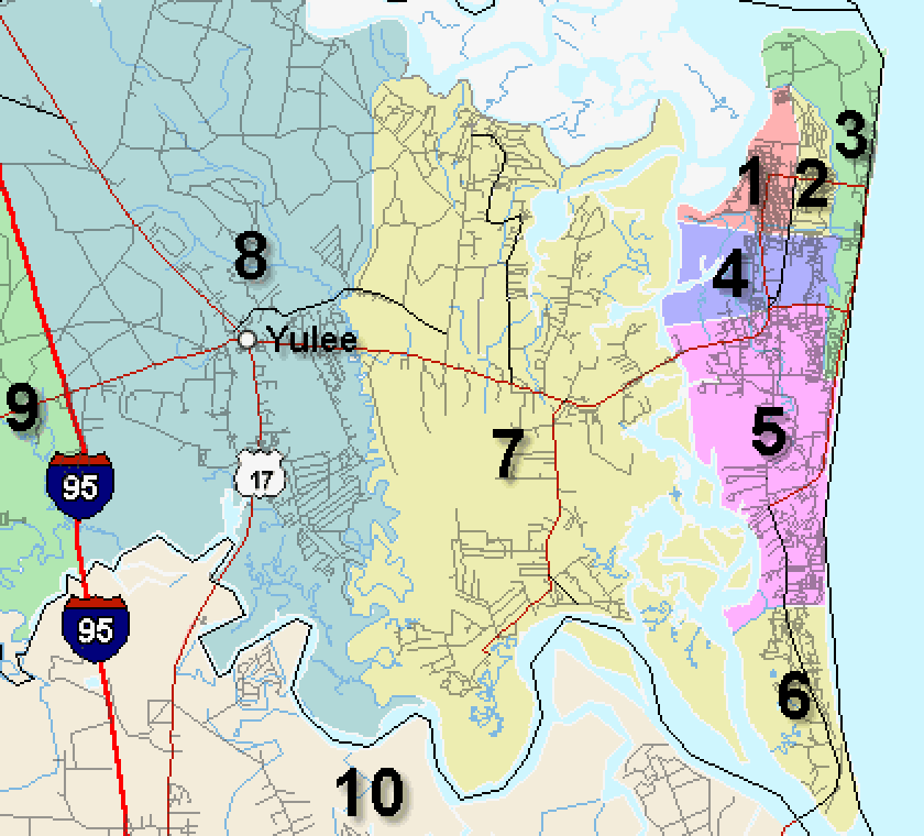
7
|
Mainland West of Intracoastal Waterway, East of Lofton Creek
Street Index |
| 70 -
|
Piney Island and Marsh Lakes |
| 71 -
|
Blackrock to include Pirate's Woods, Barnwell Road, Oyster Bay, and everything
East of Lofton Creek, South of St. Mary's River and North of A1A. |
| 72 -
|
O'Neil, Nassauville, Amelia Concourse, Holly Point and everything East of
Lofton Creek, South of A1A to the Intracoastal Waterway |
|
|
|
8
|
Mainland Yulee West of Lofton Creek
Street Index |
| 80 -
|
Everything West of Lofton Creek, East of I-95, North of A1A to the St. Mary's
River (State line) |
| 81 -
|
Everything West of Lofton Creek, East of I-9 5 and South of A1A to the County
line. |
| 82 -
|
Everything West of I-95, East of Middle Road and Griffin Road, North of County
Road 108 to the St. Mary's River (State line) |
| 83 - |
Everything West of I-95, East of Middle Road and Griffin Road , South of County
Road 108 to A1A. |
| 84 - |
Everything West of I-95, East of Griffin Road as projected, South of A1A to the
County Line. |
| 85 - |
Everything with the WILDLIGHT Village (Radiant Properties) |
|
|
|
9
|
Mainland Hilliard, Callahan, Bryceville South to County Line
North to State line.
Street Index |
| 90 -
|
Hilliard - Everything West of Middle Road, East of County Line, North of Saul
Road, Rowe Road, and County Roads 108/121 Intersection. |
| 91 -
|
Callahan, Everything West of Griffin Road, East of County line, South of Saul
Road, Rowe Road, and County Roads 108/121 Intersection, North of Thomas Creek
Road and Crawford Road. |
| 92 -
|
Bryceville, Everything South of Thomas Creek Road and Crawford Road to the
County lines. |
|
|
|
10
|
Southside/Manadarin Jacksonville Borders: St
John's River to the North, Phillips Hwy/US 1 to the East, Duval/St. Johns
county Line to South, St. John's River to West.
|
|
|
11
|
Southside Jacksonville Borders: St.. John's River
to the Hart Bridge to Atlantic Blvd on the North, Intracoastal Waterway on the
East, Duval County Line on the South and Phillips Hwy/US 1 to the West. |
|
|
12
|
Arlington/Ft. Caroline Jacksonville Borders: St.
John's River to the North, Intracoastal Waterway on the East, Atlantic Blvd on
the South and St. John's River on the West. |
|
|
13
|
Riverside/Avondale/Ortega/Wesconnett Jacksonville
Borders: I-10 to the North, St. John's River to the East, I-295 to the South,
and I-295/103rd Street/Timuquana Road/Ortega River/Roosevelt Blvd to the West. |
|
|
14
|
Westside Jacksonville Borders: 1-10 on the North,
Roosevelt Blvd/Ortega River/Timuquana Road/103rd Street/I-295/Blanding Blvd on
the East, Duval County Line on the South and West. |
|
|
15
|
East Jacksonville Borders: Trout River to the
North, St. John's River to the East and South, I-95 to the West. |
|
|
16
|
Marietta/Paxon Jacksonville Borders: Old Kings
Road and Moncrief Road (extended to the county line to the North. I-10 to the
South and Duval County Line to the West. |
|
|
17
|
North Jacksonville Borders: Duval County line to
the North, Atlantic Ocean to the East, the St. John's River (East of I-95) and
Old Kings Road/Moncrief Road extended (West of I-95) to the South and the Duval
County Line to the West. |
|
|
18
|
Orange Park Borders: A line drawn south along the
St. John's River, North West up Black Creek, North on CR 209, Northeast on CR
220, North on Little Black Creek, East along the Duval County Line to the St.
John's River.)
|
|
|
19
|
Middleburg Vicinity Borders: A line drawn South
on Little Black Creek, then Southwest on CR 220, South on CR 209, South CR 739,
South on CR 218, West on SR 16 (excluding Penney Farms) North along the
Bradford/Baker County Line and East along the Duval County Line. |
|
|
20
|
Keystone Heights Vicinity Borders: A line drawn
South on Sauders Road, South on Hogarth Road, Southwest along Putnam County
Line, North along Alachua/Bradford County line, East on SR 16 (excluding Penney
Farms) |
|
|
21
|
Oceanfront - Duval County - Ponte Vedra
SA 1 - Atlantic Beach. Borders: Bounded on North by the St. John's
River and on the South by Atlantic Blvd.
SA 2 - Neptune Beach. Borders: Bounded on North by Atlantic
Blvd and on the South by Seagate Ave/20th Avenue NO.
SA 3 - Jacksonville Beach. Borders: Bounded on the North by
Seagate Ave/20th Ave No. and on the South by County Line.
SA 4 - Ponte Vedra Beach /North Guana State Park. Borders:
Bounded on the North by the County Line and on the South by Guana State Park
and East of A1A.
SA 5 - South Ponte Vedra Beach/Vilano Beach. Borders: South of
Guana State Park bounded on the North by Guana State Park and on the South by
St. Augustine Inlet. East of A1A. |
|
|
90
|
Out of Area |
|